• Skip to main content
  • Skip to footer

Bitterroot Info

Information about the Bitterroot Valley

  • Activities
    • Hiking the Bitterroot Mountains
    • Fishing the Bitterroot River
    • Events in the Bitterroot Valley
    • The Bitterroot Trail
    • Bitterroot Valley Cultural Attractions
    • Bitterroot Valley Scenic Drives
  • Communities
    • Corvallis
    • Darby
    • Florence
    • Hamilton
    • Lolo
    • Stevensville
    • Victor
    • Small Charming Towns of the Bitterroot Valley
  • Events
    • All Events
    • Concerts & Performances
    • Exhibits, Shows & Sales
    • Fairs, Festivals & Parades
    • Farmers Markets
    • Fundraisers & Benefits
    • Holiday Celebrations
    • Submit Your Event
  • Fishing
    • Fishing the Bitterroot River
    • Essential Bitterroot River Fly Fishing Gear
    • Montana Fishing License
    • Bitterroot River Fishing Reports
    • Bitterroot River Streamflow
    • Fly Shops in the Bitterroot Valley
    • Montana Trout Test
  • Food & Drink
    • All Food & Drink Establishments
    • Bakeries, Cafés & Coffee Shops
    • Bars, Beers, Wine & Cider
    • Casual Dining Restaurants
    • Coffee & Drinks Kiosks
    • Fast Food Options
    • Food Trucks & Trailers
    • Steakhouses & Fine Dining
    • Submit Your Establishment
  • Lodging
    • All Lodging
    • Bed & Breakfasts
    • Cabin Rentals
    • Hotels & Motels
    • Large Vacation Rentals
    • Pet Friendly Vacation Rentals
    • Ranches, Lodges & Resorts
    • Riverfront Vacation Rentals
    • RV Parks in the Bitterroot Valley
    • Stay Where Yellowstone was Filmed
    • Vacation Rentals
    • Darby, MT Lodging
    • Submit Your Lodging
  • Nature
    • The Bitterroot Mountains
    • The Bitterroot River
    • The Sapphire Mountains
    • Trapper Peak
    • Lake Como
    • Painted Rocks Reservoir
    • Skalkaho Falls
    • The Bitterroot Flower
    • Montana Huckleberry
    • Morel Mushrooms
  • Random Info
    • The Bitterroot Valley
    • Bitterroot Valley History
    • Bitterroot Valley Images
    • Bitterroot Valley Map
    • Bitterroot Valley Population
    • Bitterroot Valley Weather
    • 5 Reasons To Visit The Bitterroot Valley
    • What About Glacier and Yellowstone National Parks?
    • Where Was Yellowstone Filmed? In Montana’s Bitterroot Valley
    • Bitterroot Cabins is now Bitterroot Info
  • Real Estate
    • Real Estate in the Bitterroot Valley
    • Corvallis Market Report
    • Darby Market Report
    • Florence Market Report
    • Hamilton Market Report
    • Lolo Market Report
    • Stevensville Market Report
    • Victor Market Report
image of the bitterroot river at high water levels

Bitterroot River Streamflow


image of the bitterroot river at high water levels

There are 4 Bitterroot River streamflow monitoring stations.

Three stations are on the main stem of the river, near Darby, Victor, and Missoula.

The fourth station measures streamflow on the west fork of the Bitterroot River below Painted Rocks Reservoir.

This article provides a 10 day chart for each of the Bitterroot River streamflow monitoring sites.

Content may include affiliate links. As Amazon Associates, we earn from qualifying purchases at no cost to you


bitterroot valley businesses


Bitterroot River Streamflows

If you like to fish or recreate on the Bitterroot River, you should keep an eye on streamflows.

Understanding current water conditions is the key to a safe day on the river.

It’s amazing how much Bitterroot River streamflows change throughout the year.

image of the upper bitterroot river at low water

Upper Bitterroot River at Low Water / Bitterroot Info

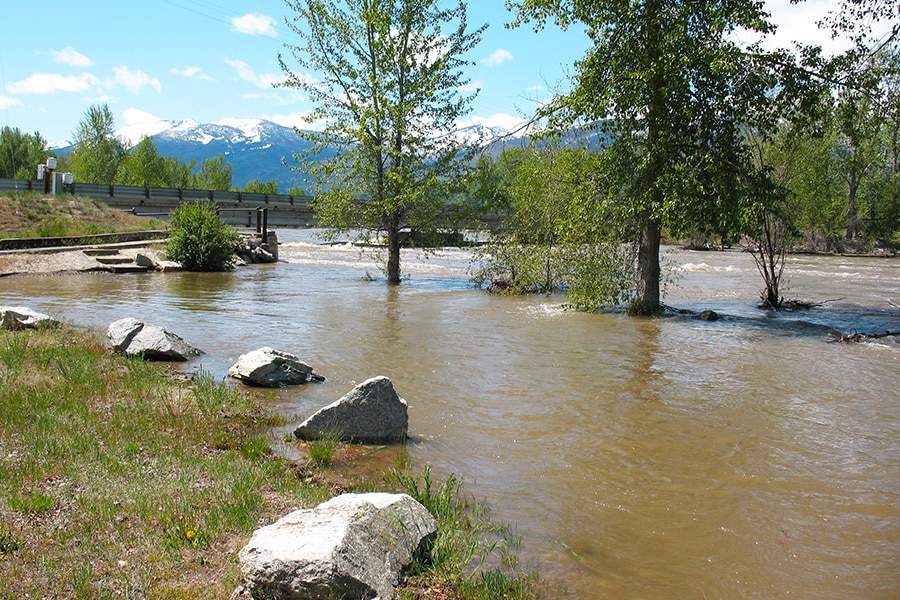
From high water in spring, to low water in the fall, streamflows can range from below 500cfs to over 10,000cfs.

That’s a factor of 20X, and the Bitterroot River is two entirely different rivers at these flows.

Be sure to take a minute to review streamflows before you head out to the river.


popular articles on Bitterroot Info


Streamflow Near Darby, MT

This is the streamflow at the beginning of the Bitterroot River, just south of Darby.

This site is located at the confluence of the East and West forks of the Bitterroot River.

Bitterroot River near Darby

©BITTERROOT.INFO
Bitterroot River near Darby
Streamflow (cfs), past 10 days.
Currently 1,630 cfs (Jun 17, 7:15 AM).
Source: U.S. Geological Survey.

This graph charts the flow rates from the Darby station for the past 10 days.

You can view an interactive version of the Darby chart on the USGS page for this station.


bitterroot valley lodging


Streamflow at Bell Crossing

This site measures streamflows of the Bitterroot River at Bell Crossing, located here.

This is the streamflow near the middle of the Bitterroot River.

Bitterroot River at Bell Crossing near Victor

©BITTERROOT.INFO
Bitterroot River at Bell Crossing near Victor
Streamflow (cfs), past 10 days.
Currently 3,850 cfs (Jun 17, 7:30 AM).
Source: U.S. Geological Survey.

This graph charts the flow rates from the Bell Crossing station for the past 10 days.

You can view an interactive version of the Bell Crossing chart on the USGS page for this station.


bitterroot valley real estate


Streamflow Near Missoula, MT

This is the streamflow near the end of the Bitterroot River, located here.

This site measures streamflow just before the confluence of the Bitterroot River and Clark Fork River.

Bitterroot River near Missoula

©BITTERROOT.INFO
Bitterroot River near Missoula
Streamflow (cfs), past 10 days.
Currently 4,550 cfs (Jun 17, 7:00 AM).
Source: U.S. Geological Survey.

This graph charts the flow rates from the Missoula station for the past 10 days.

You can view an interactive version of the Missoula chart on the USGS page for this station.


West Fork Bitterroot River Streamflow Near Conner

The Conner site measures streamflows of the West Fork of the Bitterroot River.

The site is located just below Painted Rocks Reservoir.

West Fork Bitterroot River near Conner

©BITTERROOT.INFO
West Fork Bitterroot River near Conner
Streamflow (cfs), past 10 days.
Currently 278 cfs (Jun 17, 7:15 AM).
Source: U.S. Geological Survey.

This graph charts the flow rates from the Conner station for the past 10 days.

You can view an interactive version of the Conner chart on the USGS page for this station.


bitterroot valley businesses


More Bitterroot Valley Fishing Articles

If you’re over 12, you’ll need a Montana fishing license to fish. Our calculator will show you what it will cost.

Check out our Fishing the Bitterroot River article for great information about fishing our favorite river.

Can you tell what kind of trout you just caught? Take our Montana trout test and find out.

image of the lower bitterroot river

Lower Bitterroot River / Bitterroot Info

Our essential fly fishing gear article will help get you get started fishing in Montana.

The local fly shops will help you catch more fish, and stay safe in the process.

Check out the latest fishing reports from all the local sources in the Bitterroot and Missoula.


bitterroot valley real estate


That’s a Good Question

When is high water on the Bitterroot River?

High water on the Bitterroot River normally begins in early May and continues into mid-June.

When is low water on the Bitterroot River?

Bitterroot River water levels drop to their lowest levels in late summer, typically near the end of August or early September.

Does the Bitterroot River flood?

Yes. Local flooding is common all along the Bitterroot River and its tributaries during high water.


Additional Resources

Current Montana Fishing Regulations can be found here.

Montana Fishing license information can be found here.


Related Content

fishing the bitterroot river
BITTERROOT RIVER fishing gear
riverfront vacation rentals

join us • Bitterroot Info

Written by Bitterroot Info · Categorized: Fishing

Footer

  • Privacy
  • Contact
  • Advertise

© 2026 · Bitterroot Info